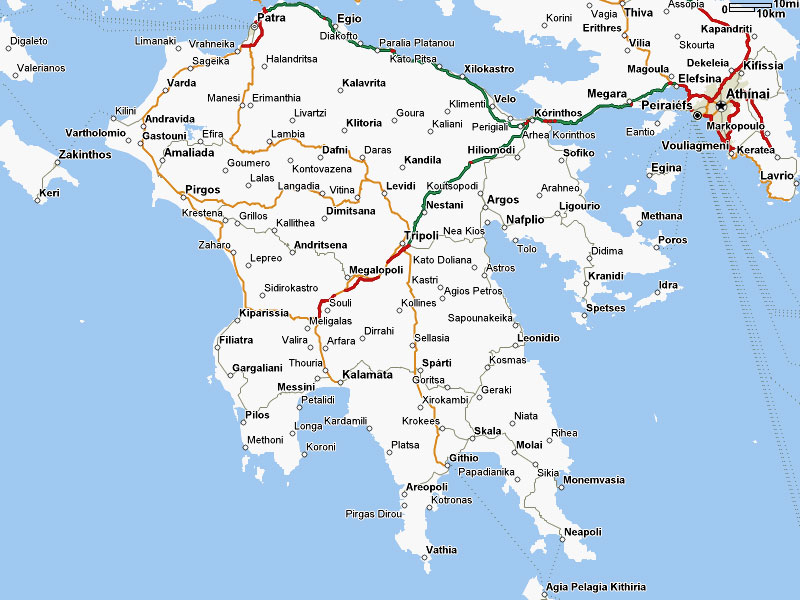
The entrance to Hades is a cave near the southernmost tip of Greece. Leading to this and the three fingers of Greece pointing towards Africa is a land steeped in legend and marked by remains of the many civilisations that have occupied the area over 5000 years.

The Peloponnese always seemed less accessible than other
parts of Greece, but this is an illusion. Now, with a good road heading from Athens
to Kalamata the whole area is reached within 3 hours.
Nafplio is a short drive, less than 2 hours, from Athens airport and
provided us with a pleasant and convenient base for reaching a host of important ruins
including Corinth, Mycenae, Epidavrus.
 |
| Nafplio from south showing town beach |
Sparta famously defeated Athens, but there are not many visible remains of the ancient city. Nearby Mystra is on the edge of the
Taygetus Mountains which bound the Spartan plain to the West.
 |
| Mystra - castle and town with Sparta in the distance |
Here are ruins of a completely different kind. On the slopes
below a hilltop castle built by the Franks in the 1200s are the remains of a
medieval Byzantine city with many churches and chapels that remain intact, most
with frescoes in various states of repair.
 |
| One of the main routes through Mystra |
The site was compulsory purchased by the government in 1953 to develop as a tourist attraction. Like many Greek sites the content is enormous and to restore it to a level where the totality makes sense to a visitor is an impossible task. One can however imagine the narrow and steep streets of a more modern Greek towns developing from these early origins.
The interior of the churches and chapels are covered in frescos and much of the painting seems rather crude. The stories and how the figures are depicted was strictly controlled by the church and these rules were codified in the 16th century.
 |
| Frescoed ceiling - church in Mystra |
There is a well built road over the mountains to Kalamata
and the plain of Messinia. This ridge heads down the middle of the Mani to the
most southern tip of Greece where it was believed a cave leads into Hades.
Patrick Leigh Fermor jumped off a boat and thoroughly explored the cave in the
1950s and found no other exit.
 |
| Exo-Mani - looking south over Kardamyli |
 |
| North towards Kardamyli with Kalamitsi beach and Leigh Fermor's house in the forground |
Fermor lived in Kardymyli on the west side of this
peninsula. We chose the nearby town of Stoupa for our next stop. This is a real
beach resort. Before this, each stopping place – be it museum, or ancient site,
or beach had a few tourist, but not many. So it was a bit of a shock when we
arrived in the evening and found the bars and restaurants all abuzz with
hundreds of English people.
While many stay in the town moving between beach and
restaurant, this area is also popular for walking in the hills. We found it too
hot for much walking in mid-September.
 |
| Abandoned olive oil factory looking down to Kardamyli |
|
 |
| Abandoned house in the village of Prastio in the hills above Kardamyli |
|
 |
| Ruined Monastery in the hills above Kardamyli |
|
 |
| The foundations of a bastion of the fort at Koroni |
 |
| The fort at Methoni |
We stayed at Pylos, overlooking a spectacular natural
harbour famous for the ‘accidental’ battle of Navarino involving a joint fleet of Russian,
French, and British ships against the Ottomans.
 |
| Voudokilia view from Paleokastro |
Our hostess explained the 4 incarnations of Pylos. The
current one is built below a fort constructed by the Ottomans in the 16th
century. They relocated from Voudokilia with the Paleokastro constructed by
the Franks in the 13th century. Nearby are many remains from
Mycenaen times (3000 BC) but the main settlements for this period and the
classic era are yet to be found.
 |
| One of the lakes at Polilimnio |
One of the popular attractions in this area are the falls of
Polilimnio. A gorge channels a river from pool to pool down between the hills.
The local soil renders a bright blue colour in the water. We clambered up the
steep path clinging to giant staples in the rock face. As we reached the top a dramatic storm started with torrential rain and thunder like a gun
battery banging just over our heads. Fortunately there was a road which took us
back down to the car park.
Pylos is a 3 hour drive to Athens airport, giving us time to
visit ancient Messene on our return for an evening flight. This is a large site with remains of an impressive 9km long wall
surrounding the wider area.
 |
| The site of Ancient Messene |
 |
| The northern 'Arkadian' gate to Messene |
 |
| Roman washroom for the gymnasts |
What you need to know.
Andrew Bostock's guide, now in its second edition provides coverage of the whole area. We sourced our maps in the UK from
Stamfords - they have a supply of driving and walking maps.
The Frytag and Berndt road map was a disappointment – although up-to-date some features were not well represented. I had read
that this was hard to handle in the car and indeed it is necessary to stop and
get out of the car when turning the map, without this it will get badly
torn. There’s an airport in Kalamata served by ‘budget’ airlines from the UK,
but Athens is just 3 hours drive away. Our car was supplied CarDelMar, a German
company. The price was reasonable, the local company met us with the car at
arrivals and took it back at departures.


No comments:
Post a Comment